Architizer’s Tech Directory is a database of tech tools for architects — from the latest generative design and AI to rendering and visualization, 3D modeling, project management and many more. Explore the complete library of categories here.
Every architectural project starts with a meticulously drawn survey. In fact, the project’s success is often largely attributed to the amount of detail and care an architect puts into their survey drawings. Still, a successful survey is not necessarily a collection of plans, dimensions and annotations. It varies from 3D scanning objects to environmental site metrics and even more abstract recordings such as smell, sound and material texture.
Consequently, impressive leaps in technology have created tools that help architects capture their sites precisely, efficiently and time-consciously. Through features such as 3D scanning, digital sketching, photographic overlay and even Bluetooth laser measuring systems, what was once a rough pen-on-paper process has now become a meticulous and seamless workflow.
Without further ado, here are the top eight tools that unlock unprecedented capabilities in architectural surveying. You can read more about each and search for other tech tools for architects in our Tech Directory:
Explore Architizer’s Tech Directory
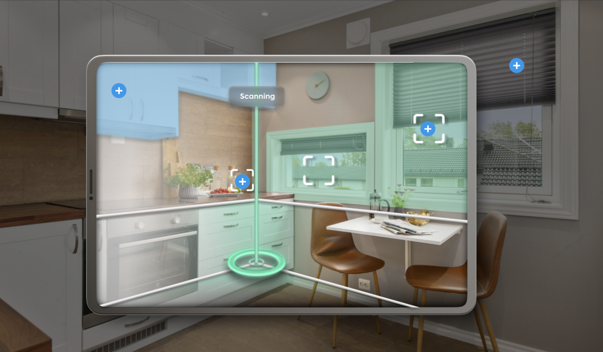
Canvas
Best Tool for Survey Scanning
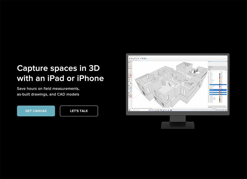
Canvas combines LiDAR data with its own computer vision technology to scan spaces. The software can be downloaded on a phone or tablet and is ideal for quick, 3dimensional surveys. Simply by moving the device, Canvas takes thousands of measurements in seconds and generates an editable 3d model. It is a high precision tool that also offers drawing services to architects, delivering as-built 2D drawings and BIM models.
Cyncly | Room Survey
Best Tool for Precision Surveying
Cyncly | Room Survey is a revolutionary drafting software which connects with laser measuring devices via bluetooth. Instead of the traditional hand sketching, architects can now see their survey become materialized through the Cyncly | Room Survey app, simply by measuring with their laser. All room dimensions are transferred on a digital drawing and 3d model, which can then be exported in multiple formats.
Magicplan
Best Tool for Photographic Surveying
 Magicplan is the ideal tool for photographic surveys. Simply by taking photos of the space, this software tool can transform images into 2D drawings and 3D models. Its most groundbreaking feature is its ability to automatically detect architectural elements through each photo such as doors, windows and even electrical outlets. Magicplan also includes an asset library with furniture models, appliances as well as plumbing and structural systems that can be used to populate each survey.
ARPLAN 3D
Best Tool for Augmented Reality Surveying
ARPLAN 3D is essentially a ruler operating in Augmented Reality. It can be downloaded on phone and tablet devices and uses spatial technology to measure surfaces. Once the measurement starts, a surface plane appears on the device’s screen, clearly marking the area’s dimensions. The measure data can be then easily translated into a plan drawing.
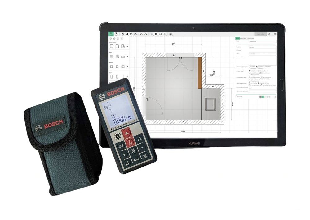
MeasureOn by Bosch
Best Tool for Construction Surveys
MeasureOn by Bosch combines digital sketching and laser surveying to deliver highly accurate floor plans. Architects can draw a sketch of their space and carefully edit its dimensions via the app. Through the software, photographs of specific architectural elements such as doors and windows are combined with laser measuring, clearly marking their dimensions. Finally, the app integrates an innovative annotation system that allows architects to include notes on their drawings as well as an additional calculation feature, which can determine the floor’s surface area and the room’s perimeter, automatically.
OrthoGraph
Best Tool for Generating BIM Surveys
OrthoGraph’s most revolutionary feature is generating drawing surveys and models compatible with BIM technology. It incorporates digital sketching tools, bluetooth laser compatibility as well as the ability to produce reports and calculations through the measured data. Finally, OrthoGraph includes a 3d walkthrough feature, allowing architects to become immersed into the space and examine every surveyed detail.
Q-Mobile
Best Tool for Real Estate Surveys
Q-Mobile is a surveying app that collects data for diverse valuation reports such as RICS Level 2 HomeBuyer Reports and Single Survey Reports. This innovative tool supersedes conventional paper-based site notes, enabling surveyors to efficiently finalize property valuation and inspection reports directly on-site. The app also includes digital sketching and photo capture features.
Planimeter
Best Tool for Outdoor Site Surveys
Planimeter is a surveying tool for outdoor site analysis. It measures distances and land areas on maps. Architects can simply search for a location by address and measure by dropping pins on the map. It can calculate plots of land as well as fences, bridges, buildings and even street lengths — essentially anything that is visible on a satellite map.
How to Better Leverage Survey Tools in Architecture
The following tips and considerations will help you maximize the potential of surveying tools in architecture, as well as avoid common pitfalls associated with this fast-emerging technology.
Give surveys character: Nowadays, most survey tools strive for automation, aiming to deliver quick, accurate results. Still, site surveying should preserve the space’s more covert qualities such as its materiality, light conditions and general ambiance, elements that complement the design process. Therefore, it is important to enrich the digitally generated drawings and models with the more “atmospheric” site conditions.
Calibration is the secret to successful surveying: Ensure that survey tools are properly calibrated for accurate measurements. Especially when using tools that include technologies such as augmented reality or photometric scanning — which register large amounts of spatial information — it is important to double check data to avoid any errors.
“Real-Time Data Capture” is the future: The most revolutionary aspect of these new survey technologies is the fact that architects are able to capture measurements on-site. Such tools enable them to verify the data and address any discrepancies onsite, reducing the likelihood of errors and the need for revisits.
Architizer’s Tech Directory is a database of tech tools for architects — from the latest generative design and AI to rendering and visualization, 3D modeling, project management and many more. Explore the complete library of categories here.