Architects: Showcase your next project through Architizer and sign up for our inspirational newsletter.
The National Association of City Transportation Officials has released a handy guide to temporary street reconfigurations to facilitate safer and more efficient services and activities during the COVID–19 crisis. The document comprises a variety of 3D diagrams, each showing different ways that streets can be reprogrammed for different stages of the pandemic, including the expansion of pedestrian zones, safe outdoor dining, space for emergency services, and layouts for safe protest.
“Adaptive use of streets can lead the global response and recovery to this crisis, keeping people safe and moving while holding cities together,” said Janette Sadik-Khan, Chair of the National Association of City Transportation Officials and Principal at Bloomberg Associates. The following 15 diagrams suggest just some of the ways in which streets can be utilized for different functions throughout the crisis, with an eye to more permanent solutions in post-pandemic urban planning.
1. Critical Services
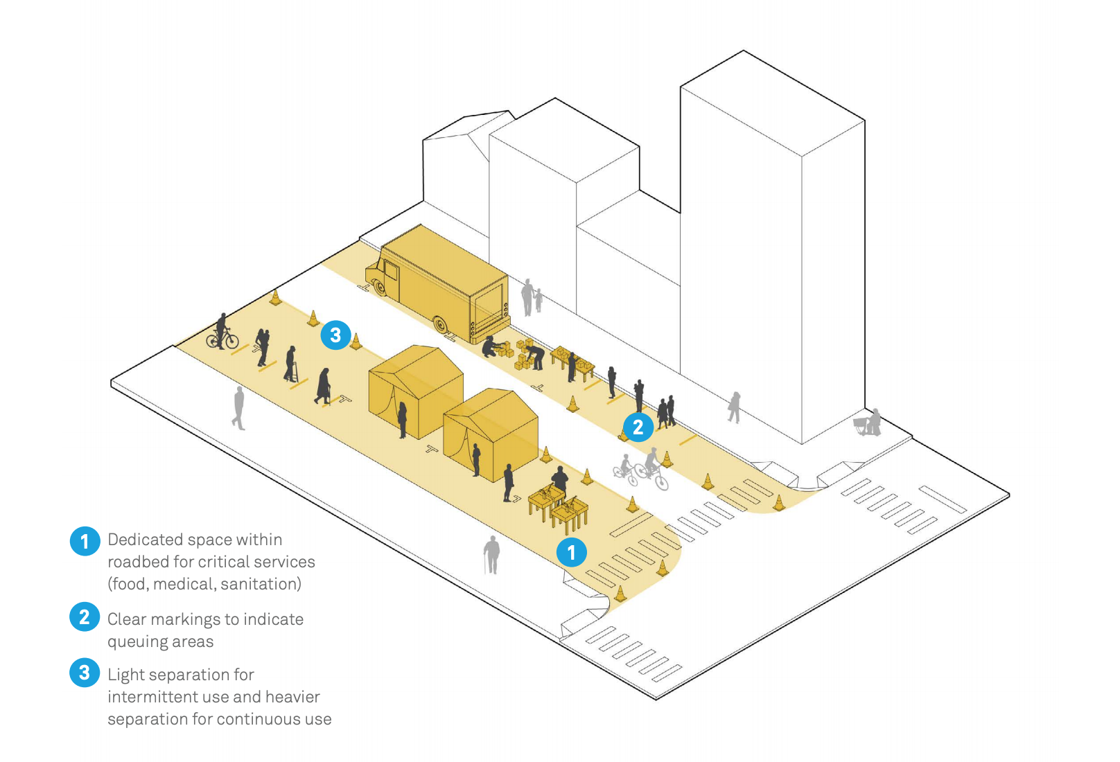
Goal: Provide space for critical/temporary food, sanitation, health, medical, or social services distribution centers.
Context: Near key essential destinations such as markets, clinics, community centers, and transit stops. Adjacent to hospitals or medical centers that require additional capacity.
Key Steps
- Identify and prioritize relevant locations based on city demographic/health data and medical center locations.
- Work with local medical centers to forecast where expanded capacity might be needed.
- Fully or partially close streets to erect tents, distributions centers, or mobile stations.
Timeline: Days to weeks.
Duration: Hours, days, weeks or months.
2. Managing Speeds
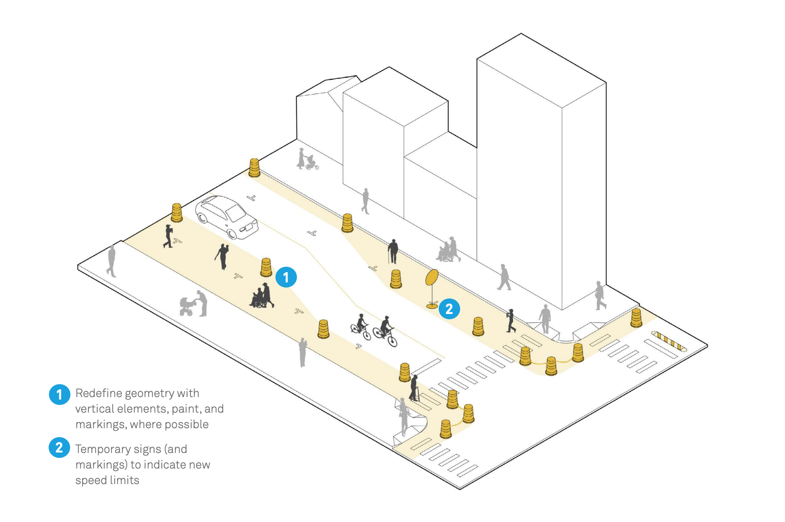
Goal: Manage vehicle speeds to enhance the safety of all street users.
Context: Streets with long, straight stretches or inadequate traffic-calming infrastructure; intersections with wide turning radii. Wide, typically congested streets currently experiencing higher vehicle speeds. Citywide speed limit reductions, critical corridors; specific streets, intersections and zones.
Key Steps
- Reduce the posted speed limit to a level consistent with eliminating serious injuries and update markings and signs.
- Deploy quick-build designs and/or pair with other street or public space interventions.
- Publicize speed limit and anti-speeding message with media campaigns.
Timeline: Days to weeks to plan, hours or days to implement.
Duration: Days to months.
3. Sidewalk Extensions
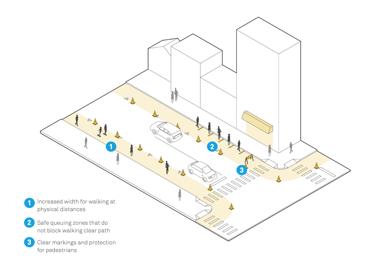
Goal: Provide space for people to comply with physical distancing guidelines while walking or waiting.
Context: Along main/high streets and major thoroughfares with essential businesses/services, high transit use, or crowded recreational paths. On streets with narrow or missing sidewalks that cannot be converted to local traffic only.
Key Steps
- Convert curbside parking or motor vehicle lane to pedestrian space.
- Protect lane with reflective barriers such as freestanding delineators or traffic barrels.
Timeline: Days to plan, hours to implement.
Duration: Days to months.
4. Safe Crossings
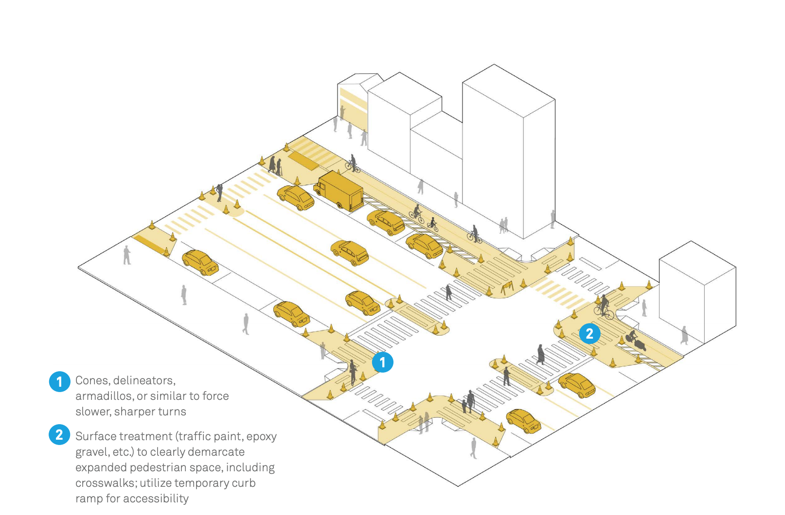
Goal: Improve crossings to help people walk/ bike safely given increased volumes and changing travel patterns.
Context: Crossings at or near essential services (pharmacies, hospitals, grocery stores, transit stops, parks, etc.) Mid-block locations with high crossing demand, especially on multi-lane streets. Streets with transit stops at unsignalized locations, fast or high-volume traffic, and/or high crash rates.
Key Steps
- Use vertical elements to delineate curb extensions or refuge islands.
- Shorten crossing distance and reduce speeding by repurposing or narrowing vehicle lanes.
- Apply reflective traffic tape or paint to delineate pedestrian space and increase crosswalk visibility.
Timeline: Days.
Duration: Weeks, months, years.
5. Slow Streets
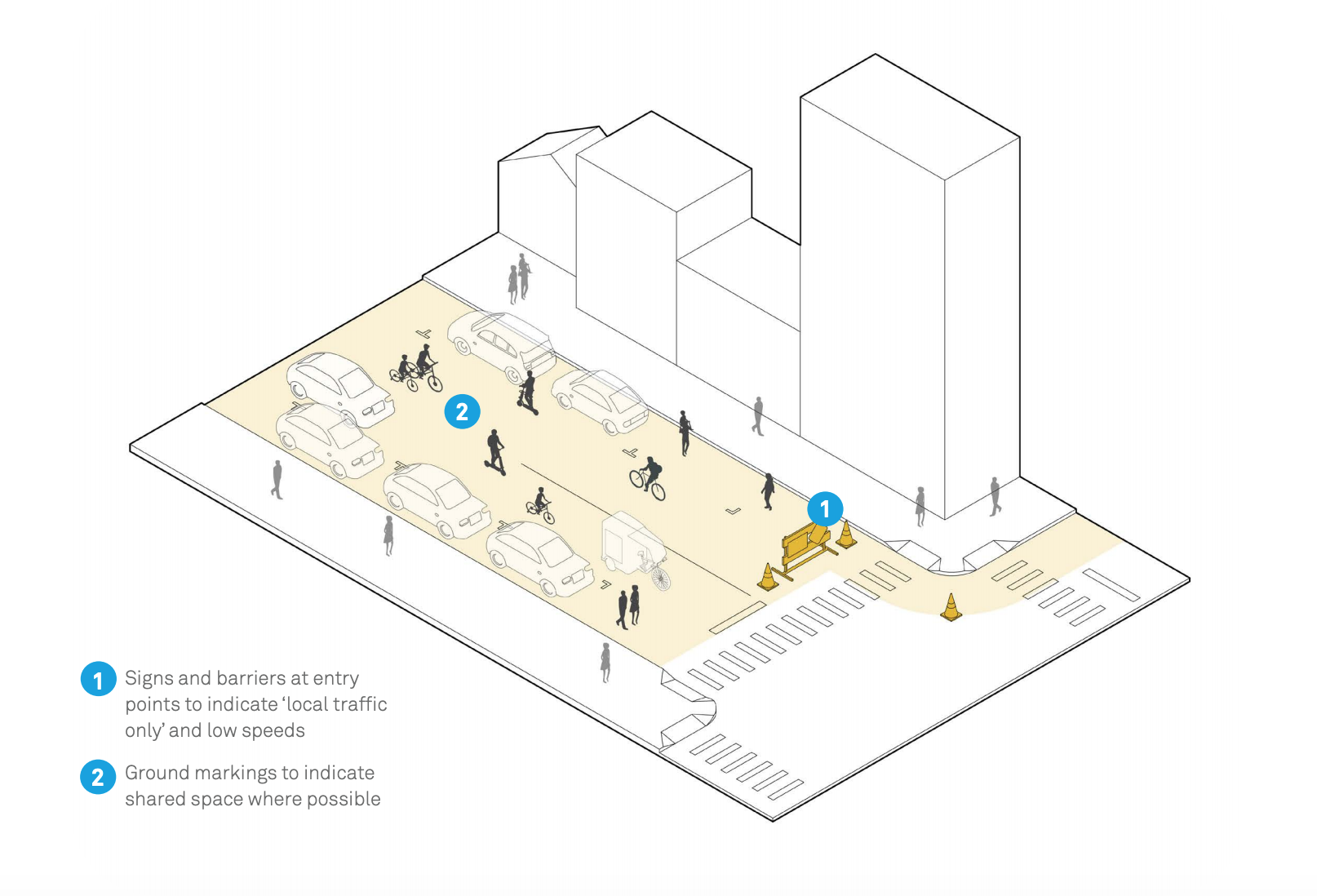
Goal: Reduce traffic volume and speed to a minimum so that people can walk, bike and run safely.
Context: Streets with low vehicle volume and low to moderate speeds, where vehicle volumes have dropped, or serve redundant through-traffic role during COVID disruptions.
Key Steps
- Install temporary traffic barriers and “Local Traffic Only”, Slow/Shared, or branded signs (e.g. “Stay Healthy Streets”) at main vehicle entry points.
- For neighborhoods, establish a grid of entry points into the local street network where barricades should be installed.
- Identify stewards to take care of and monitor barricades.
- Allow local access, deliveries, and emergency vehicles.
Timeline: One week.
Duration: Days to months.
6. Open / Play Streets
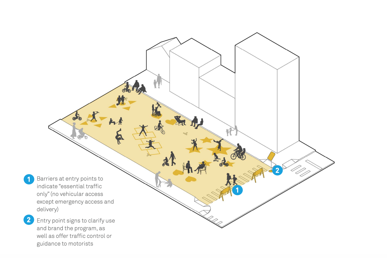
Goal: Provide safe space for physical activity, play, distant socializing, etc.
Context: Parkways or waterfront corridors with few intersections. Low-volume residential streets. Commercial streets with local restaurant/retail clusters and no transit.
Key Steps
- Install temporary traffic barriers and “Emergency Vehicle/Delivery Only” signs at intersections.
- Establish grid of entry points into local streets where barricades should be installed.
Timeline: One week.
Duration: Time of day, day of week, weekends, or ongoing (weeks, months).
7. Bike and Roll Lanes
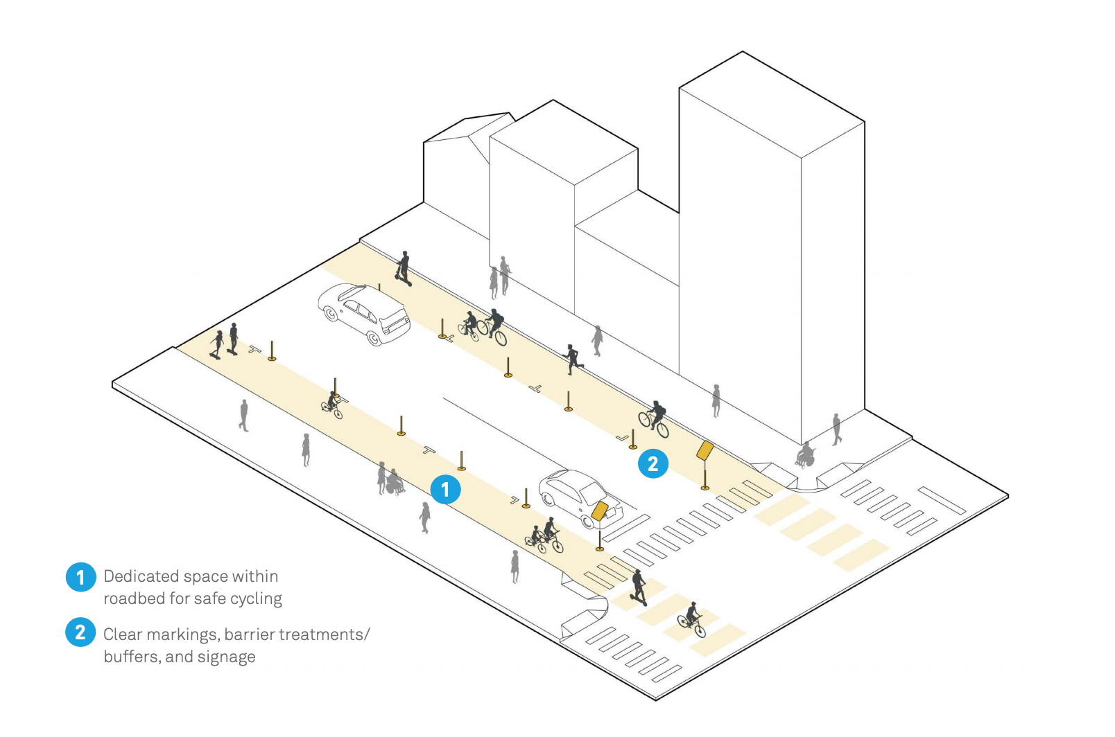
Goal: Provide space for essential workers and others to bike and roll safely while maintaining sufficient physical distance from others.
Context: Multilane streets, streets with wide lanes where demand is high. Streets that provide access to hospitals and other essential services; connector routes to parks and other open spaces.
Key Steps
- Convert curbside parking or motor vehicle lane to bike lane. Optional: convert adjacent vehicle lane to passenger or freight loading, or parking.
- Designate start of lane with a barrier and sign, positioned so as not to block cyclists.
- Use reflective barriers such as traffic cones, flexible posts, bollards, plastic barriers, freestanding delineators, or traffic barrels.
Timeline: Days to plan, hours to implement.
Duration: Days to months.
8. Transit Lanes
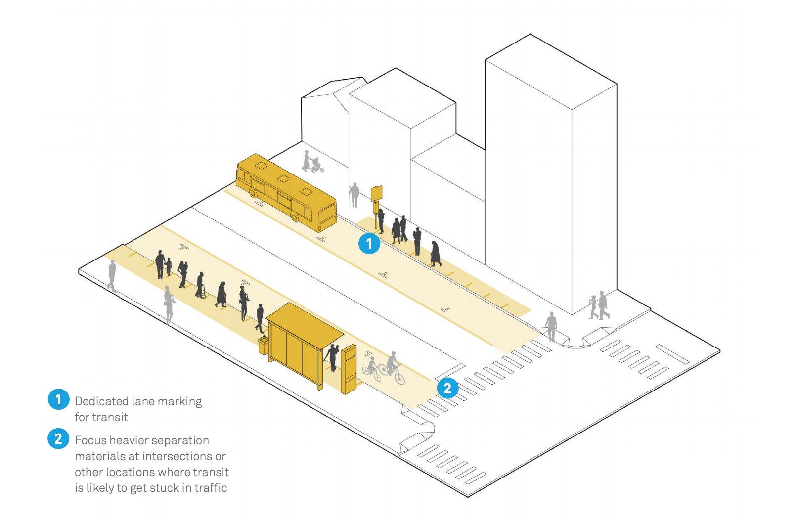
Goal: Provide or expand transit-only/ transit-priority lanes to make onstreet transit a reliable and efficient form of transportation for the people who need it most.
Context: High-ridership transit corridors and routes that serve transit-dependent communities and essential businesses/services.
Key Steps
- Convert curbside parking or motor vehicle lanes to surface transit lanes.
- Designate the transit lane with lane markings, regulatory signs, electronic signs if available, and vertical elements such as cones.
Timeline: Weeks to plan, days/weeks to implement.
Duration: Several months to two to three years.
9. Transit Stops and Access
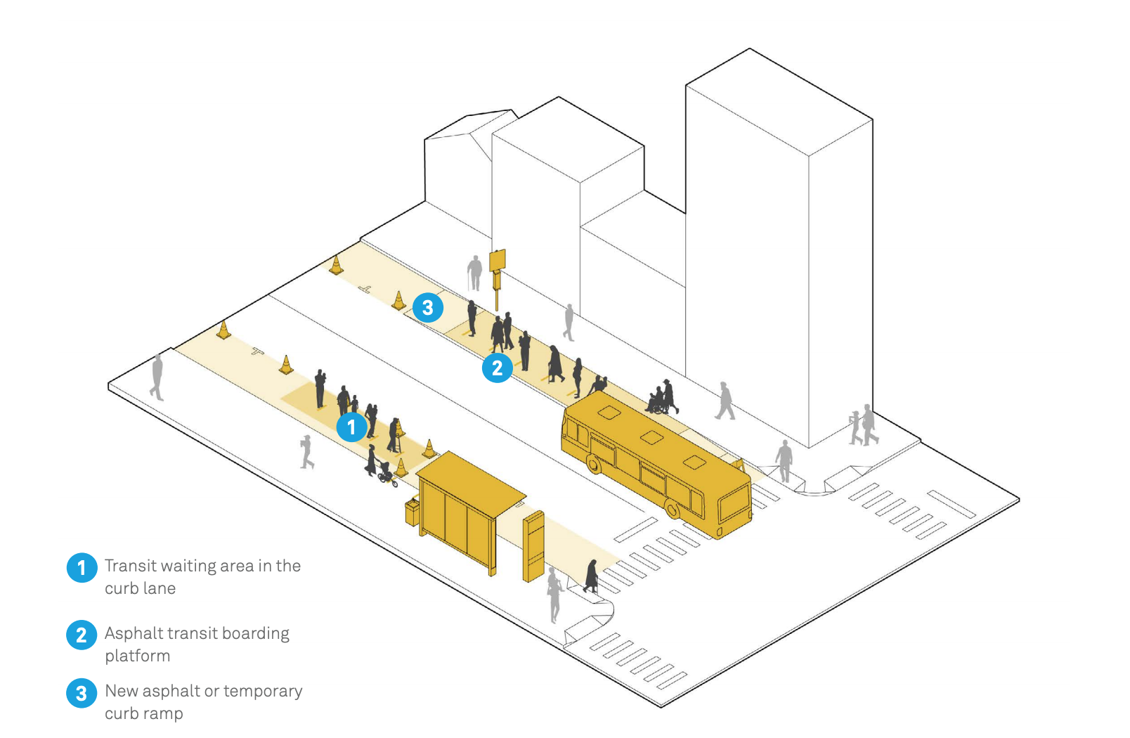
Goal: Provide sufficient waiting area for transit passengers and allow reardoor/all-door boarding to reduce queuing and boarding time.
Context: Transit stops with high daily boardings or boardings concentrated at specific times of day. Transit stops on sidewalks that are too busy or too narrow for physically distant waiting.
Key Steps
- Deploy platforms with interim materials, such as curbs plus asphalt and modular islands
- Install ramps, crosswalks, and safety islands to access mid-block stops.
- Ease rear boarding via mobile ticketing, on-board contactless payment, and off-board fare collection.
Timeline: Days to weeks to plan, hours to weeks to implement.
Duration: Months to years.
10. Pick-Up and Delivery Zones
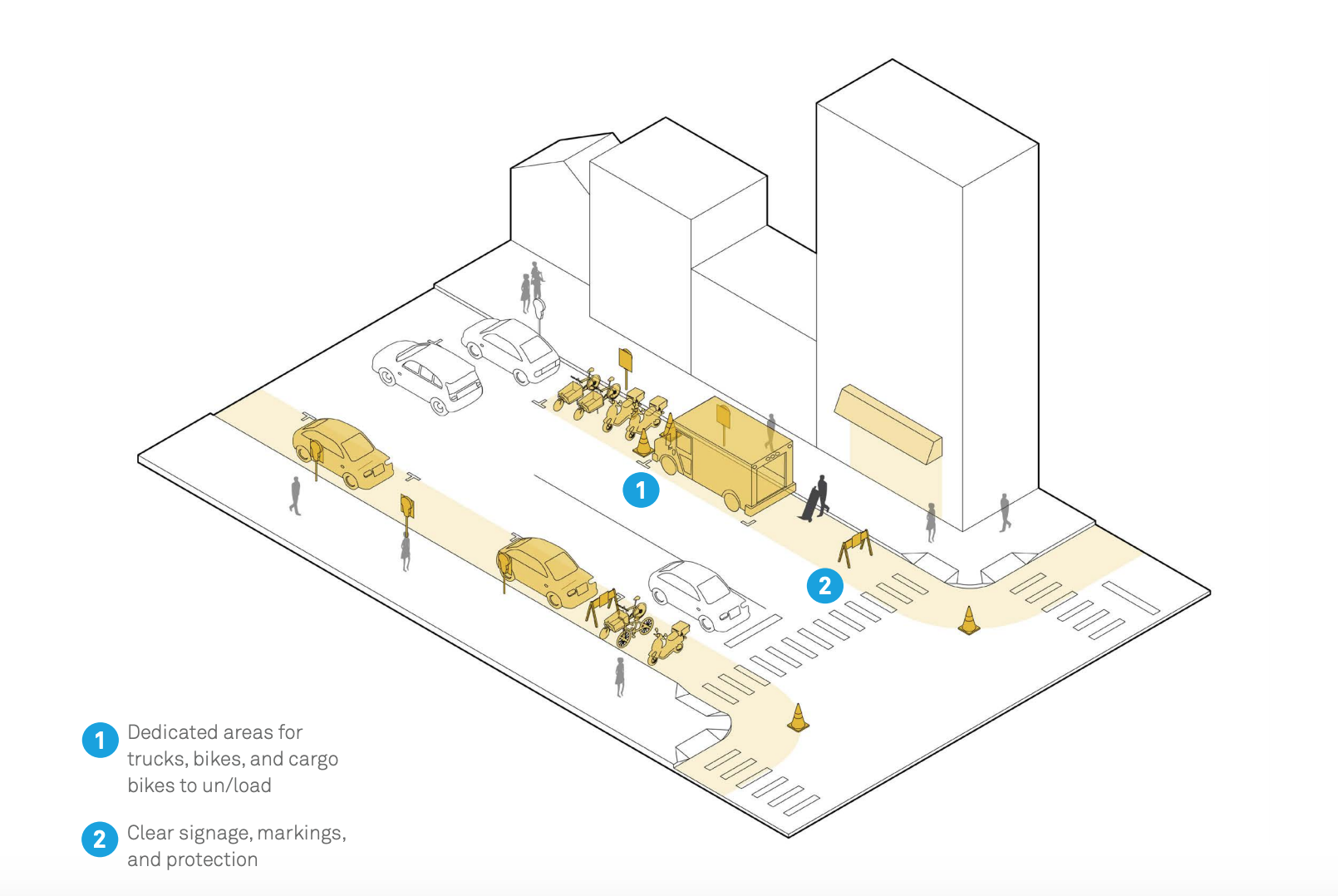
Goal: Convert curbside parking spaces or travel lanes to high-turnover pick-up or delivery zones serving essential businesses.
Context: Most relevant at restaurants, laundromats, pharmacies, and other essential services.
Key Steps
- Use spray chalk, paint, stickers, or traffic tape, as needed to delineate space.
- Alter management and enforcement policy, and cover meters or machines.
- Set time limits (~10 minutes max.) to enable turnover/quick access to essential services.
Timeline: Days to plan, hours to implement.
Duration: Days to months.
11. Outdoor Dining
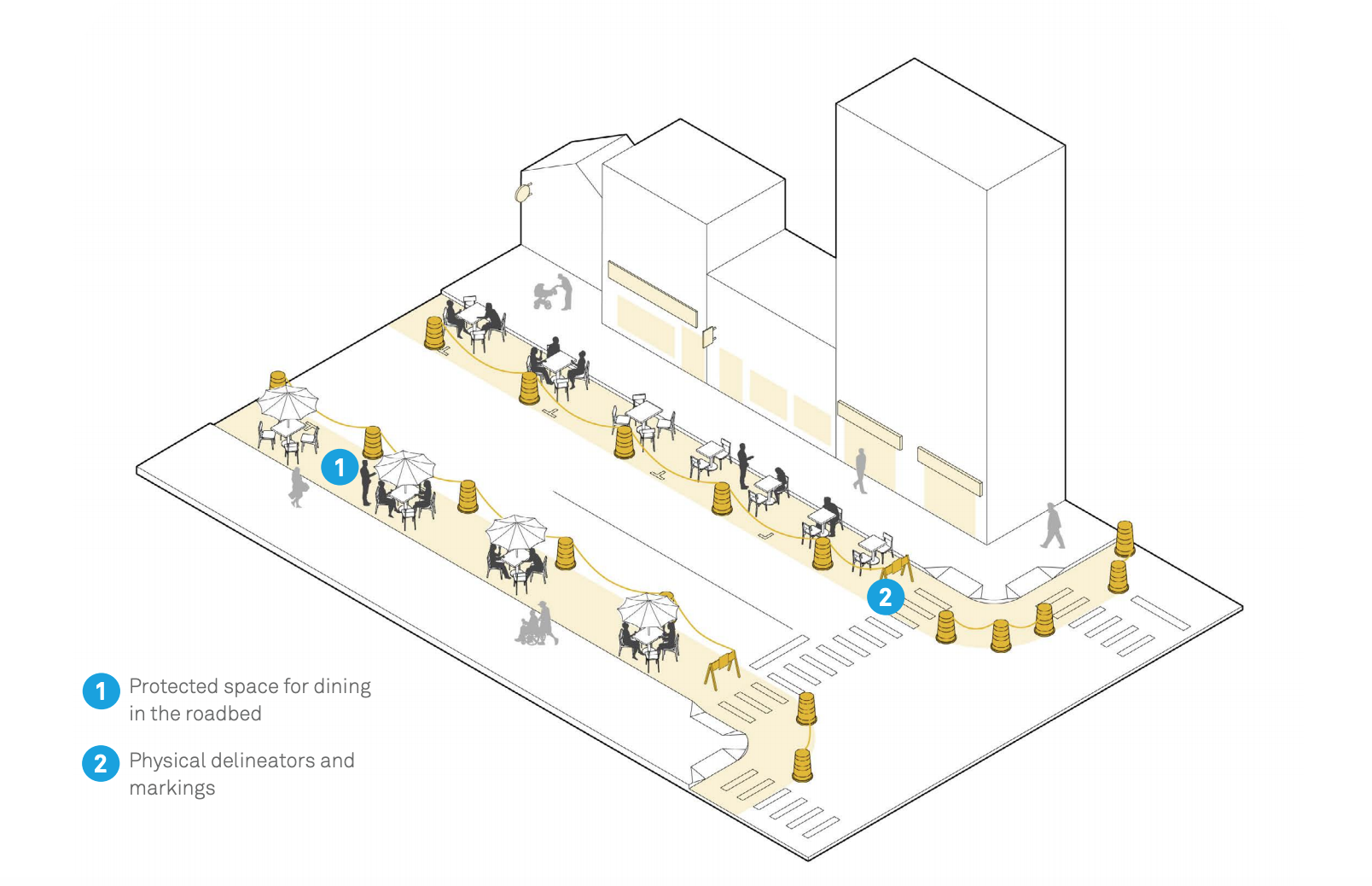
Goal: Provide space for outdoor dining so that restaurants can comply with physical distancing guidelines while resuming dine-in operations.
Context: Where restaurants, cafes, food stalls, and/or street food vendors are clustered along several blocks.
Key Steps
- Identify restaurant clusters and designate ‘dining street’ zones.
- Waive existing permit fees for outdoor dining within preselected zones, as necessary.
- Establish clear occupancy standards (e.g. table counts) for ‘dining street’ zones.
Timeline: One week.
Duration: Months.
12. Markets
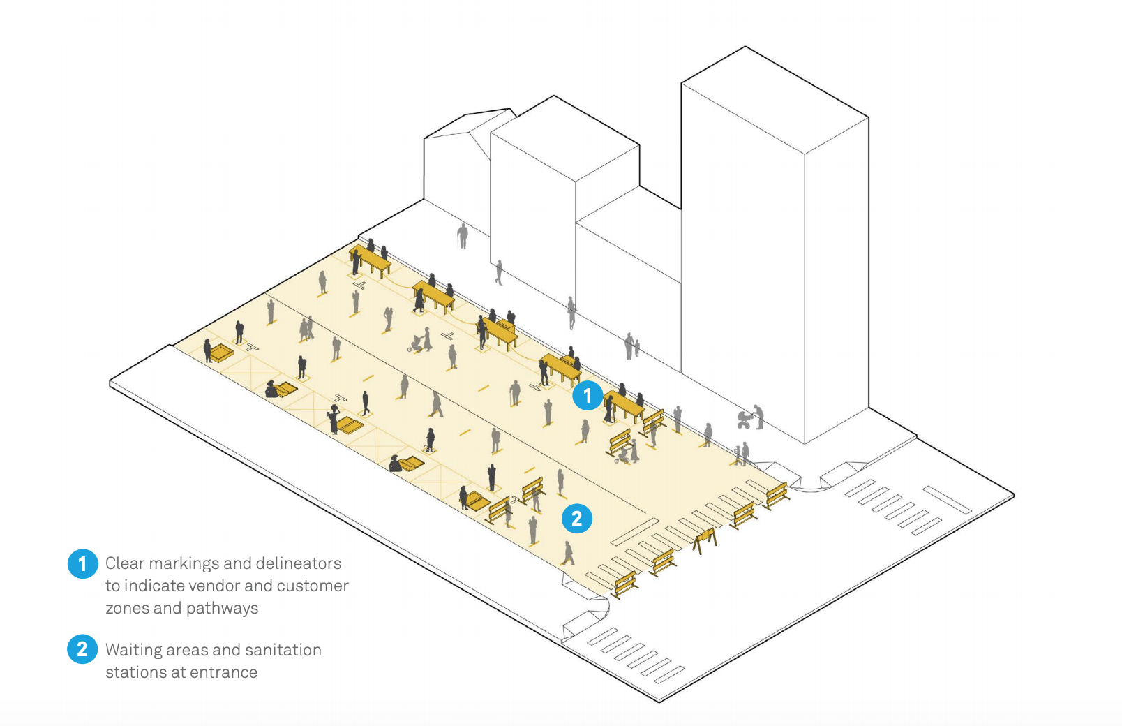
Goal: Expand market footprints into adjacent streets to relieve crowding and support physical distancing.
Context: Streets with permanent or active open-air markets. Streets adjacent to market buildings or public spaces with markets. Periodic farmers markets.
Key Steps
- Allocate street space to allow markets an expanded footprint to operate with safe physical distancing.
- Alter management and enforcement policy.
- Define safe layout and spacing for vendor stalls and circulation routes based on local physical distancing guidelines.
Timeline: Days to plan, hours to implement.
Duration: Hours, days, months, or permanent.
13. School Streets
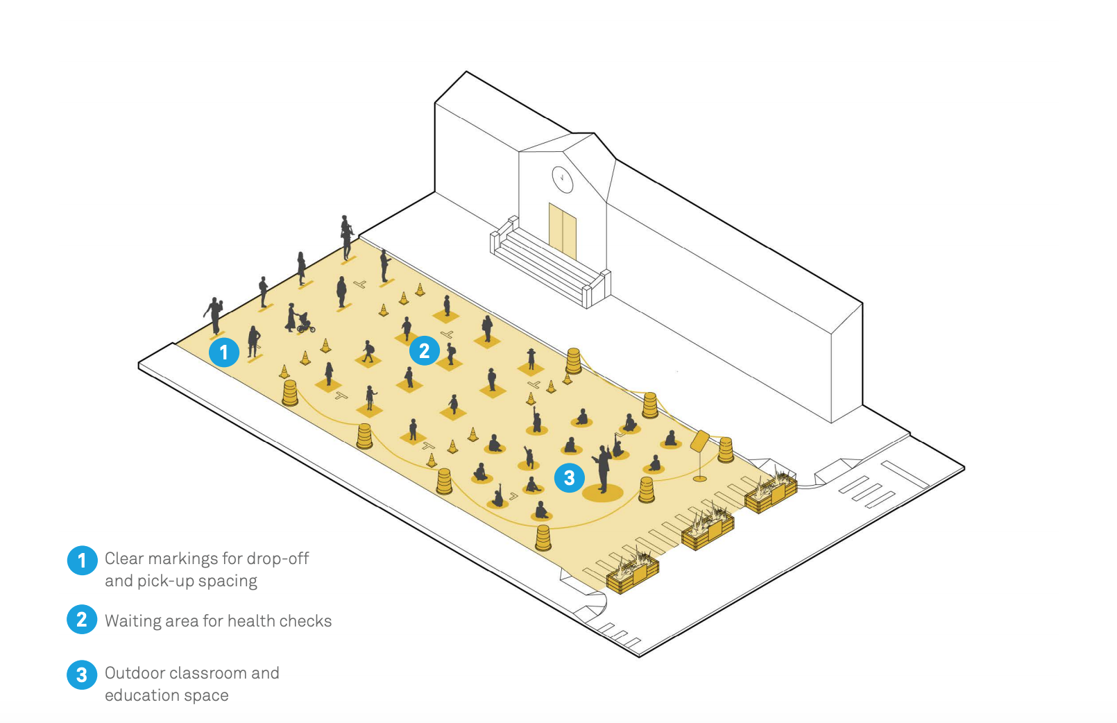
Goal: Provide outdoor classroom and recreation space, and safe pick-up/ drop-off and health check zones.
Context: Streets and parking lots adjacent to schools, daycares, and facilities used by students and children. Streets near and around schools used as routes for walking and rolling to school.
Key Steps
- Provide car-free on-street space for schools and care facilities to conduct classes and hold recess and assemblies.
- Create safe routes to schools using expanded sidewalks, bike and roll lanes, safe crossings, and speed management.
Timeline: Days to weeks to plan, hours to implement.
Duration: Hours, months, or long-term.
14. Streets for Protest
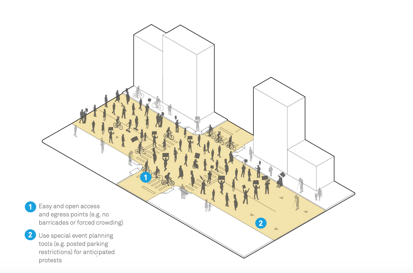
Goal: Facilitate safe access to public spaces for demonstration and protest as a fundamental civic right.
Context: Iconic parks, streets, and squares typically used for demonstrations or rallies. Decentralized in neighborhood public spaces and streets. Large streets and bridges; locations of community or historical significance.
Key Steps
- Iconic parks, streets, and squares typically used for demonstrations or rallies.
- Decentralized in neighborhood public spaces and streets.
- Large streets and bridges; locations of community or historical significance.
Timeline: Hours to days.
Duration: Days, weeks, months.
15. Gatherings and Events
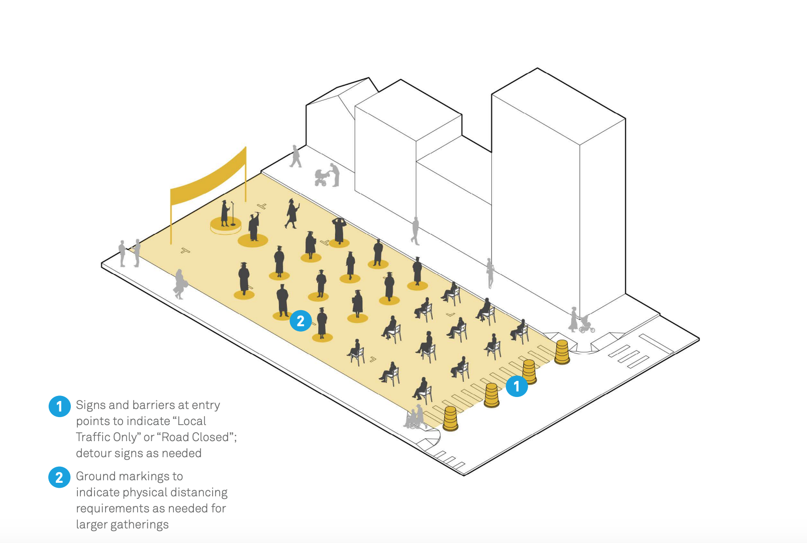
Goal: Use full or partial street closures to provide outdoor space for cultural, religious, or civic gatherings.
Context: Low-volume residential streets, laneways, or pedestrian streets. Commercial streets or other corridors with no transit. Multi-lane streets with low vehicular volumes. City or organization-owned parking lots and open-air garages.
Key Steps
- Install temporary traffic barriers and “Local Traffic Only” or “Road Closed” signs matching closure type.
- Identify agency and local stewards to install and monitor barricades during events.
- Ensure access for essential deliveries and emergency vehicles.
Timeline: Days to one week.
Duration: Hours, days, weeks.
Check out the complete PDF guide Streets for Pandemic Response & Recovery for more details and context around the above diagrams.
Architects: Showcase your next project through Architizer and sign up for our inspirational newsletter.
Top Image via Condé Naste Traveller